

Learn more about this story
Project Webstory
Go to webstory
Pastoral livestock production contributes 46% of agricultural GDP and is key to LAC's food and social security. Currently, pastoral bovine production systems face the challenge of increasing their profitability by reducing their environmental impact, since high costs and a growing concern about their contribution to global warming threaten their development. Knowing the quantity and quality of available biomass is key to making management decisions that improve the productive efficiency and profitability of these livestock systems, while enabling the monitoring, reporting and verification of the effect of GHG emission mitigation strategies. However, frequent field measurements that cover an entire property are expensive and often impractical. Over the last five years, the availability of satellite data on a spatial and temporal scale compatible with weekly management decisions of individual paddocks has advanced enormously, and prediction models of the quantity and quality of biomass based on remote sensors are starting to appear. For this technology to result in productive improvements, it is necessary to have reliable, locally validated models and mechanisms that make the information available to different users. The main objective of this project is to lower the cost of estimating in real time and with adequate precision the quantity and quality of biomass available in pastoral livestock systems through a satellite tool. The project is funded by the New Zealand Government as part of its contribution to the Global Research Alliance on Agricultural Greenhouse Gases (GRA).
Lower the cost of estimating in real time and with adequate precision the quantity and quality of biomass available in livestock systems in LAC through a satellite tool.
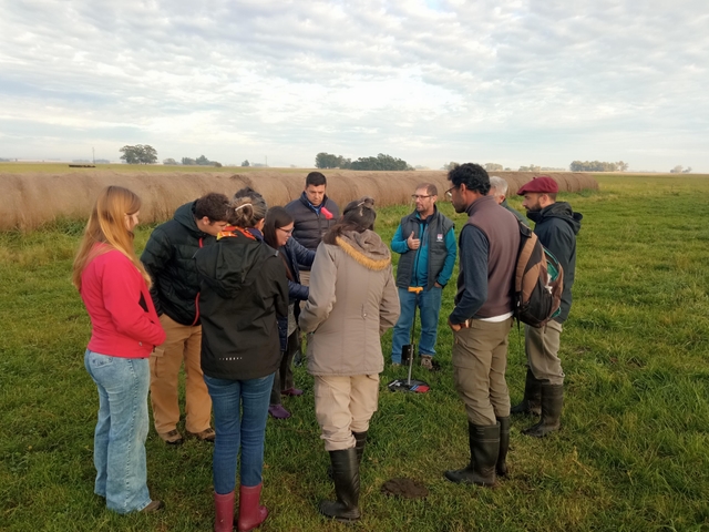
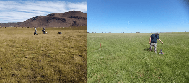
Three key tools were developed to advance the satellite monitoring of forage biomass quantity and quality in grasslands: a field sampling protocol, a mobile application for recording field observations (biomass and forage quality), and a web platform for visualizing collected data and supporting sampling activities. These tools enabled the establishment of a monitoring network with the active participation of more than 79 researchers and technicians. The database currently contains approximately 3,600 records (1,600 collected directly under the standardized protocol and 2,000 obtained through indirect methods). Using these data, machine learning models (Random Forest) were evaluated with Sentinel-1 and Sentinel-2 satellite imagery. The relationship between biomass and satellite-derived variables showed strong spatial and temporal variability, resulting in paddock-scale prediction errors (RMSE) of 820 and 612 kg DM/ha (~41% and 32%) when considering all forage resources and temperate pastures from Balcarce, respectively. In contrast, the relationship between satellite data and forage quality (crude protein content) proved to be more consistent and generalizable. These findings supported the development of two simplification tools that integrate satellite and field data to improve estimation accuracy. The first is a spatial simplification approach that optimizes sampling through measurements at strategically selected locations (corresponding to extreme spectral index values). The second is a temporal simplification approach that estimates real-time forage stocks by integrating residual biomass measurements with forage growth models. Both tools were validated under real farming conditions, achieving operational errors of approximately 20%, and contribute to sustainable livestock management based on scientific evidence. Dissemination and training activities reached more than 3,500 participants.
The direct beneficiaries of the project are, on the one hand, livestock producers in pastoral systems of Argentina, Uruguay, Colombia and Costa Rica, who will have information that will allow them to improve grazing management decisions and therefore forage harvesting and profitability of their systems; and on the other hand, the government entities in charge of GHG emission inventories that will be able to more accurately quantify the magnitude and intensity of GHG emissions and thus monitor, report and verify the effectiveness of national mitigation policies.
This project actively contributes to achieving the Sustainable Development Goals, promoting more equitable, resilient, and sustainable regional development.


Martín Durante
ArgentinaFernando Lattanzi
UruguayLiliana Atencio Solano
ColombiaJosé Pablo Jiménez Castro
Costa RicaMariano Oyarzábal
ArgentinaAlejandra Casal
ArgentinaAndrea Bolletta
ArgentinaAriela Cesa
ArgentinaCarlos Saúl Navarro
ArgentinaCecilia Caruso
ArgentinaDiiego Bendersky
ArgentinaEmanuel Caluva
ArgentinaFlorencia Jaimes
ArgentinaJosé Otondo
ArgentinaLibertario González
ArgentinaLisandro Blanco
ArgentinaLucas Butti
ArgentinaMartín Andersen
ArgentinaPablo Barbera
ArgentinaRaúl Diaz
ArgentinaRoxana Ávila
ArgentinaRoxana Ledesma
ArgentinaSebastián Lagrange
ArgentinaÚrsula Wolf
ArgentinaEmilia Lopez Seco
ArgentinaGarcía Martínez Guillermo Carlos
ArgentinaNicolás Bertram
ArgentinaCarlos Rojas Navarro
Costa RicaEbed Villalobos Vargas
Costa RicaRonin Hurtado Palacios
Costa RicaSilvia Rivas González
Costa RicaWilliam Sanchez Ledesma
Costa RicaJose Edwin Mojica Rodriguez
ColombiaJose Jaime Tapia Coronado
ColombiaJose Luis Contreras Santos
ColombiaWilson Andres Barragán Hernandez
ColombiaDavid Felipe Nieto Sierra
ColombiaEdgardo Agustín Devia
ArgentinaJosé Luis Rivera
Costa RicaGustavo Contenti
ArgentinaLuca Scenna
ArgentinaThe tangible impact of science and technology in the field
Sponsors


With the support of


